“Sans Souci Cable Ferry Returns to Service Saturday” – Read the article here.
Save Sans Souci Ferry
S. Riggs, 5-9-2020
A serious blow has just been dealt to the long-term development of the Windsor Water Hub. The NC Dept. of Transportation announced that for financial reasons they are terminating the contract ($85,000/year) for the historic and famous Sans Souci Ferry across the lower Cashie River as of July 1, 2020. We must preserve this working piece of transportation history that is critical for the ongoing sustainable eco-tourism business within the Windsor Water Hub and the Bertie Water Crescent. Saving the Sans Souci Ferry is equally as important as preserving and/or locating other local historical sites such as the Hope Plantation, Cashy Court House, former Native American villages, location of previous homes of historic explorers (Nathaniel Batts) or politicians (Governor Pollock), and even the potential location of the “Lost Colonists” (Site X ).
The NC LOW report titled “Rivers to Sounds” (2018) lays the ground work for establishing a series of Bertie County Water Hubs, that will provide the foundation for developing 1) a world class, sustainable eco-tourism business for the Windsor Water Hub and 2) the possible future designation as the Bertie Water Crescent National Water Trail System. Obtaining this national recognition from the US National Park Service would provide a national marketing tool for the unparalleled natural beauty and eco-tourism opportunities within the “Bertie Water Crescent”. The Windsor Water Hub on the black waters of the beautiful Cashie River extends from the upstream boat ramp at the mouth of Hoggard’s Mill Run, through Windsor, and downstream to boat ramp at Sans Souci (means “without worry”). The Town of Windsor sits at the heart of the Cashie River boating trail with its’ waterfront park, boardwalks, boat ramps, Roanoke-Cashie River Center, and Elm Street Campground and Tree House Village.
The Cashie River boating trail meanders through a vast area of swamp forest wilderness for about 25 miles. Since the river downstream of Windsor is at sea level, the flow is very gentle with fluctuations driven largely by small astronomical tides and moderate storm tides from the Albemarle and Chowan River estuaries. Most of the river is bounded by vast floodplain swamp forests with little access or development. The Lost Boat camping platform is located about 15 miles downstream of Windsor (near Johnson Mill Road) and about 5 miles upstream of Sans Souci. In addition, there is approximately 4,139 acres of forest land owned by either the Town of Windsor, Bertie County, or various North Carolina agencies that provide tremendous opportunities for further development of sustainable eco-tourism components in the future. Sans Souci is both a terminus for the gentle, black-water Cashie River boating trail system and the trailhead for the high energy, brown-water Roanoke River boating trail system with its’ ten camping platforms on the lower Roanoke River floodplain, that is managed by the Roanoke River Partners.
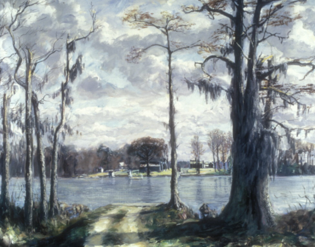
Sans Souci is the location of the NC DOT two-car, cable ferry across the beautiful, wide Lower Cashie River estuary, a true black-water wilderness. The Sans Souci ferry was made famous by Francis Speight, a nationally known artist from Windsor, NC whose impressionistic paintings of North Carolina and Bertie County hang in many national museums and galleries. Among his most famous paintings include a series titled “Sans Souci Ferry”; other Bertie County paintings include “Cashoke Creek at Shipyard Landing”, and the “Hope House”, “Tayloe House”, and “Old Smoke House”. The highly honored native son, Francis Speight, was born at Sharrock Plantation in Bertie County (1896-1989) and was the “Artist in Residence” at East Carolina University from 1961-1976.
The Sans Souci Ferry is a critical piece of transportation history in the lower Coastal Plain known as “North Carolina’s Land of Water” where small ferries operated at most landings on every major water body since human occupation. Small ferries of many types were essential factors for subsistence and the economic development of NC. The Sans Souci ferry is one of the last two-car ferries in NC, is a crucial piece of NC history, and is a critical component for the ongoing development of a sustainable eco-tourism business in the “Bertie Water Crescent”.
Bal Gra Property Acquisition
Coastal Land Trust
What an awesome picture of the Bal Gra beach, bluffs, ravines etc.?? Yes, this is a very significant component of the entire western Albemarle shoreline from the Hwy 17 bridge south through Bertie Co. property and Salmon Creek. The clay bed underlies the entire area and forms the base on which the overlying sand and muddy sand beds that form the bluff and supply the sand for the modern sandy beach. All of the black sand and white sand that forms the modern beach seaward of the bluff comes from the erosion of the bluff. The white sand is mostly quartz whereas the black sand is made up of various kinds of heavy minerals including magnetite, illmanite, zircon, rutile, tourmaline, garnets, etc. The surface of the underlying clay bed is chock full of fossil shrimp and crab burrows (all of the holes you see on the surface). Usually in the bluff (where it is exposed) there is a variable layer of ironstone (from a few inches to a foot or so) that has formed by the iron rich groundwater seeping down thru the sand bed and then flows out onto the beach–the iron precipitates at the edge of the bluff where it is oxidized.

Locally you will see little patches that are preserved on top of the clay bed and bigger broken pieces slightly offshore when the water level is low. The overlying sand and muddy sand bed that forms the major portion of the bluff, as well as the entire land surface of the Salmon Creek, Bal Gra, and Bertie Co. properties forms the Talbot Terrace which is a major feature produced by a former high stand of sea level during a previous inter-glacial warm period.
Your picture also shows an extremely important feature along the lower portion of the vertical bluff–that is a slump apron that was formed during the last major storm surge event (based on the age of the vegetation on the apron this was a storm that occurred about a decade or so ago. This now protects the bluff from further erosion until the next big storm surge event which will overtop this and produce a freshly eroded bluff and new sediment for the beach–in the meantime the vegetated slump apron is protecting the shoreline from erosion by small scale storms.
From a scientific point of view, one of the important values of preserving all three of these properties is the geologic history that not only tells the climate change story of the past several hundred thousand years of earth history, but also dictates the different ecosystems that form on the surface, as well as the human cultural history of the region.
Thanks for working so hard to preserve these incredible properties. Also, do you have any more pictures that you took when you were exploring the area? I can’t wait to spend some more time really exploring that whole area.
Acquisition of Hoggard’s Mill Run
S. Riggs, 3-31-2020
Acquisition of the ~350 acres at the mouth of Hoggard’s Mill Run, and including the old mill dam, portion of the Cashie River tributary is a critical step in the long-term development for both Windsor and Bertie County for three reasons. First, it definitely helps minimize catastrophic flooding in the Town of Windsor, and second, it forms an important natural resource component for developing an eco-tourism based economy, and third, it presents an ideal opportunity to reconstruct the cultural history of the region. A few of the more specific benefits are as follows.

1. Cashie River Flooding
A. Hoggard’s Mill Run is the largest upstream tributary of the Cashie River. The floodplain is largely vegetated with a vast timber resource, which holds much of the rainfall and slows the downstream delivery of water. Vegetation in headwater streams is critical to Cashie River flooding in three ways:
a. it lowers the level of the surrounding ground water table,
b. takes up a substantial amount of water through plant production and evapotranspiration, both of which increases the natural water storage capacity.
c. the physical presence of grasses, shrubs, and trees cause frictional drag that breaks up and slightly slows the discharge rate.
B. Preservation of Hoggard’s Mill property would represent the initial investment in a long-term program to help minimize downstream flooding in Windsor by protecting and improving the natural vegetative cover in all of the Cashie headwater streams.
a. The mill dam should be rebuilt, but with a water control structure that allows the water level in the mill pond to be managed to provide a small temporary increase in upstream water storage during major events.
b. An important part of the long-term plan to minimize downstream flooding in Windsor, is to get private land owners to put conservation easements on their lands in the other headwater tributaries upstream on the Cashie River. This not only helps to hold back flood waters, but it provides a potential source of income for the property owners.
C. If the Hoggard’s Mill Run floodplain is not preserved, there is a high probability of it being logged in the near future. Once logged the ground water and vegetation storage capacity is significantly diminished, the Mill Run becomes more like an open pipe that dramatically increases the rate of discharge. This results in increased flash flooding with increased downstream water-level rise.
D. In major flood events, just a few inches of increased water level can change the impact of a flood event in Windsor from mild flooding to catastrophic flooding.
2. Windsor Water Hub #1 From Hoggard’s Mill to Treehouse Point.
Acquisition of Hoggard’s Mill Run natural area would become the upstream cornerstone for Windsor Water Hub, important in the long-term development of a ecotourism economy built around the natural resources and cultural history of the region.
A. Provides critical natural area with abundant habitat for wild game and a major nursery area for several species of fish.
B. Enhances the opportunities associated with the Cashie River Kayak Trail. It already has a high quality boat ramp, fishing pier, and parking area on the mainstem of the Cashie River.
C. This property could be the focus for several new tree houses located at the mouth of Hoggards Mill Run.
3. Potential Development of the Cultural History of the Windsor Region.
The “Lost Town of Cashy” existed during the period 1739-1770 (H. Thompson, 1967) and was located at the head of navigation on the Cashie River, where Hoggard’s Mill Run meets the Cashie River.
A. This is the location where the following remnants exist:
a. The “Lost Town of Cashy” had the “Cashy Bridge”, a floating bridge chained to trees across the main stem of the Cashie River, just above the wharf with a hand dug turning basin for the barges and boats.
b. The old mill dam and mill pond supported both a grain and saw mill. The mill was operational continuously until about 1934.
c. There is an old cemetery still there, along with abundant evidence of brick kilns on the property.
d. The old town had the original courthouse, along with a bank, hotel, and houses.
B. Potential development of an 18th century historical site featuring the following:
a. Rebuilt mill dam with a reconstruction of a working mill.
b. Delineate location of the “Lost Town of Cashy”.
c. Develop a covered kiosk at the site of the original court house that tells “The Cashy Story”
A Natural Resource & Cultural History Based
“Rivers to Sounds Field Education Center”
Bertie County, NC
North Carolina Land of Water (NC LOW)
Bertie County
Town of Windsor
Read the full report by clicking here.
Read the October 21, 2019 meeting minutes by clicking here.

Want to know more about NC LOW?
Friends of NC LOW
A Time for Science
Albemarle-Pamlico National Estuarine Program
Alligator River National Wildlife Refuge
Bertie County
Cape Hatteras National Seashore
Cape Lookout National Seashore
Eastern 4-H Environmental Education Center
East Carolina University
ECU Coastal Studies Institute
Explore North Carolina
Kenan Institute of Engineering, Technology &
Science
Kenan Institute of Private Enterprise
Mattamuskeet National Wildlife Refuge
NC Coastal Atlas
NC Coastal Federation
Friends of NC Low
NC Coastal Land Trust
NC Dept of Commerce—Underserved & Limited
NC Natural Science Museum
NC Partnership for the Sounds
NC Sea Grant Program
NC Space Grant Program
NC Water Resources Research Institute
Pettigrew State Park
Pocosin Arts
Pocosin Lakes National Wildlife Refuge
Reisert Foundation
Roanoke River National Wildlife Refuge
Roanoke River Partners
Somerset Place Historic Site
Town of Windsor
Z. Smith Reynolds Foundation